TruPulse® Rangefinders
Professional handheld laser rangefinders with distance, height, inclination, and azimuth measurement
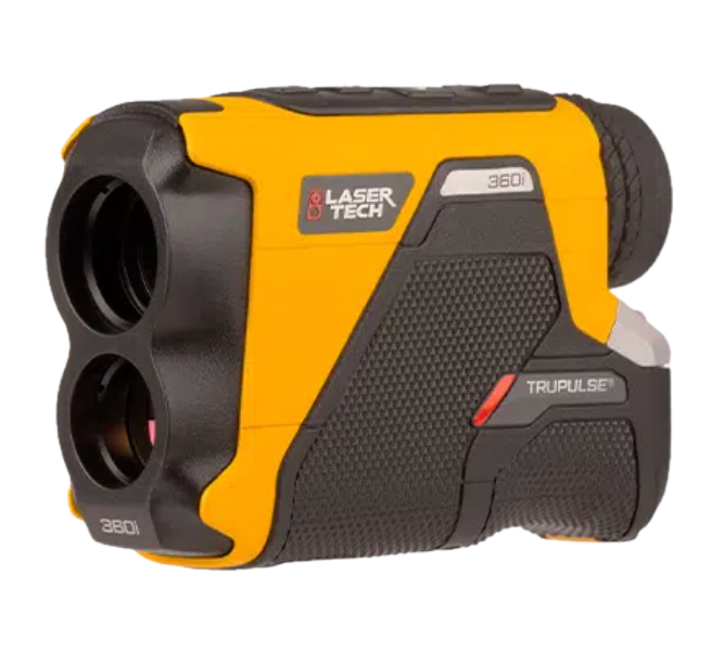
TruPulse® 360i
FlagshipAll-in-one distance, inclination, and azimuth in a single handheld device.
- 2,500m range
- TruVector 360° compass
- ±0.1m accuracy

TruPulse® 200i
ProfessionalHigh-accuracy distance and inclination without compass.
- 2,500m range
- Inclination sensor
- Height routines

TruPulse® 200X
Extended RangeExtended range capabilities for long-distance measurement.
- Extended range
- Inclination sensor
- Professional grade

TruPulse® L2
CompactLightweight, pocket-sized rangefinder with TruTargeting technology.
- 2,195m range
- IP67 waterproof
- 227g (8 oz)
Measurement Capabilities
Slope Distance
Direct line-of-sight distance measurement to any target up to 2,500m away.
Horizontal Distance
Automatically calculated horizontal distance accounting for inclination angle.
Vertical Distance
Height difference calculation between your position and target point.
Inclination
Angle measurement above or below horizontal in degrees or percent slope.
Azimuth
360° compass bearing to target with TruVector technology (360i models).
Height Routine
Two-shot measurement for object height like trees, buildings, and poles.
 LaserSoft® Connect
Free mobile app that integrates TruPulse rangefinders with ArcGIS Field Maps for laser offset mapping directly in your GIS workflow.
- Measure laser offsets to inaccessible points
- Calculate positions using distance + azimuth
- Record attributes with laser measurement data
- Works with any GNSS receiver brand
- Multiple offset calculation methods


LaserSoft® Software Suite
Additional software for laser data collection and management
LaserSoft Measure2
Quick measurement collection app for iOS and Android. Record and export laser measurements.
iOS, AndroidLaserSoft MapSmart
Desktop software for organizing and managing mapping data from TruPulse devices.
WindowsIndustry Applications
Forestry
Tree height measurement, timber cruising, stand boundary mapping, and plot data collection.
Utilities
Pole height analysis, conductor clearance measurement, sag profiling, and asset mapping.
Surveying
Offset mapping to inaccessible points, horizontal/vertical distance calculation.
GIS & Mapping
Asset inventory, feature location, and integration with ArcGIS Field Maps.
Get Started
Explore documentation for Laser Technology products